Frequently Asked Questions
Please note, the Question and Answers in this section apply to the version of the program available at the time of the question. Modifications made to the program in subsequent versions may impact the answer.
Jump To:
- Purchase, Download, and Installation
- Updating WinSLAMM Data Files
- Parameter Files
- Pollutants
- Representing Project Areas
- Streets/Alleys
- Volume/Flow
- Calibration
- Stormwater Control Practices
- Stormwater Control Practices - Street/Alley Cleaning
- Stormwater Control Practices in Series
- Stormwater Control Practices - Infiltration Practices/Cisterns
- Cost Data
- Model Input and Output
- Model Errors
Search
# Purchase, Download, and Installation
Question: I just downloaded the zip file for a program update from the website and I need a password to extract the files. Where do I get the password from?
Answer: If you purchased a new or renewal license within the past year, you should have received an email regarding the program update with the password. If you purchased a new or renewal license more than a year ago, you will need to purchase a new or renewal license. If you did not receive the password, but believe you should have, please contact PVA.
Question: Before buying this software I would appreciate seeing an example of the input and output. Can you provide examples of the WinSLAMM input / output for my review?
Answer:
- The website contains information and examples for WinSLAMM.
- Training opportunities are available. Refer to the Training Page on the website.
Dr. Pitt's research website also contains many examples of model use, such as:
Question: How do I know if I am eligible for a free version upgrade?
Answer: Review the License Renewal Policy posted on the website. Contact us if you do not have the date of purchase.
Question: If I am operating using an older version, do I need a renewal or whole new license to obtain the current version?
Answer: The renewal refers to the time that has lapsed since the last purchase, not the physical age of the program. If the last purchase was between 1 and 3 years ago, then the updated version is a renewal. If the last purchase was more than 3 years ago, then a new license must be obtained.
Question: I am looking to purchase licenses of WinSLAMM and WinDETPOND. I am located outside of the USA. Is this an issue?
Answer: At times it can be difficult to send software outside of the USA. PVA will work with you to try to get you the software, however, in certain circumstances, we may not be able to send the software to an international address. Fill out the order form and send it to PVA. PVA will contact you with options. Software sent outside the United States is subject to additional handling fees.
Question: I am requesting a password for a free update of the latest version of WinSLAMM.
I purchased the program about 13 months ago and would appreciate a one-time exception to the 1-year policy because it is so close.
Answer: PVA does not provide exceptions to the 1-year policy.
Question: Will PV and Associates, LLC provide invoices? We would like to purchase a copy of WinSLAMM but in order for our accounting department to issue a check I need an invoice, would you be able to email one to me?
Answer: Yes, PV and Associates will provide invoices. Please fill out the order form, mail (or e-mail) it to us with the request for an invoice, and PVA will send you an invoice. Once you receive the invoice, please mail the check with a copy of the order form and PVA will mail you the software package.
Question: Does PV and Associates, LLC accept credit cards?
Answer: Yes. A separate order form for credit cards is available.
Question: Does PV and Associates, LLC accept purchase orders?
Answer: PV and Associates, LLC accepts purchase orders on a very limited basis. If your situation requires a purchase order, please contact us.
Question: What is the PV and Associates, LLC refund policy?
Answer: PV and Associates, LLC will grant a refund of the cost of the software within 30 days of the date of purchase if a purchaser of the software believes the software does not perform as documented. PVA has always responded to (and welcomed) suitably documented error reports and have made every effort to correct legitimate problems. However, it is expected that the user review the available help and documentation tools for the program.
Question: I am working on some modifications to the EPA Storm Water Management Model (SWMM). As part of this effort, I am very interested in reviewing the source code for SLAMM/WinSLAMM as well as SSIP. Is it possible to obtain these and, if so, how can I go about such.
Answer: PVA does not distribute the source code for the model. There is extensive documentation for the model available directly from our web site - www.winslamm.com, including comprehensive descriptions of the program algorithms, available here
Question: I am installing the updated version of the program (version 10.x.x). How do I do this?
Answer: Using the "Remove Programs' function in the Control Panel, uninstall WinSLAMM v10. (WinSLAMM v9 and earlier do not need to be uninstalled). After uninstalling the previous version 10 of the program, navigate to where the new setup.exe file is located. Double-click on that file. The installation wizard will walk you through the remainder of the installation process.
Question: I am a relatively new WinSLAMM user, and I am encountering issues with the way WinSLAMM itself is displaying on my computer. In almost every window in WinSLAMM, it appears that the text is overlapping, or cut off in certain areas, and on certain buttons. It appears as if all of the display windows are smashed, and I am unable to resize them.
Answer: The first potential solution is to try to adjust the monitor's screen resolution. Adjust the resolution until the program is displaying correctly.
If that does not work, a second potential solution (if your computer has a Windows 7 Operating System):
- On your desktop, right-mouse click and select "Personalize"
- On the left hand side, down at the bottom, select "Display"
- Select "Smaller - 100% (default)"
Question: I installed WinSLAMM on a new computer. When I try to run the files, I get errors that it cannot find the parameter files.
Answer: Most likely the existing WinSLAMM data files have the paths to the parameter files pointing to a different location than where they are currently stored. Verify the path listed in the WinSLAMM data file against the parameter file locations. If they differ, modify the WinSLAMM data file or change the file location. The default location for the v10.x.x parameter files is the C\WinSLAMM Files directory.
Question: How many computers can a single license be installed on?
Answer: The number of licenses an entity owns is not tied to the number of computers it is loaded on, but the number of users. The program can be loaded on as many computers as needed in a single office location. However, each office location should own the number of licenses for the number of users using the program simultaneously. Additionally, licenses are not transferable between office locations.
# Updating WinSLAMM Data Files
Question: I have projects files I created in v9.2. How do I open them in v10?
Answer: At this time, v 10 (file extension .mdb) can only import v 9.4 (file extension .dat) files. To open a v 9.2 file in v10, first open and save it in v 9.4 (the Batch Editor can be used to update several files at once if needed). Then, in v 10, select "File", then "Import DAT File". Navigate to where the file is stored and select "Open".
Most control practices will be imported along with the source area data. Some control practices will not be imported due to the new program structure and those will have to be re-created in the new files.
# Parameter Files
Question: Just wondering if there is a way to model specific rainfall amounts, for example a 5.9" - 24 hour rain event (100 year event) or even a 1.25" - 1 hour event (10 year event).
Answer: A single, specific event can be modeled. To do this, create a small rainfall file. Open an existing rainfall file in a text editor (to use as a template for the required format of the rainfall file) and delete all but the number in the first row and the first two events. The rainfall file should now only have three rows. The first row is the number of events in the file, the second row is the small antecedent rain about 2 weeks before the rain of interest (to allow any stormwater controls to drain before the event of concern), and third row that has the event of interest. Change the start and end times in the third row of the file (the second rain) to the rainfall duration needed. Set the rainfall event in the third row to have a start time approximately one or two weeks later that the first event. Set the depth of the first event to a very small depth, usually 0.01 inches, and the depth of the second event to the value for the event being considered. Finally, set the number in the first row of the file to 2. This tells the model there are two rain events in the rainfall file. Save the new file with a different file name with the "ran" extension. The example below if for a 5.90 inch rain of 24 hrs duration (about three weeks after a 0.01 inch one hour event):
2
"06/21/17","12:00","06/21/17","13:00",".01"
"07/14/17","12:00","07/15/17","12:00","5.90"
Question: Is there a setting from within WinSLAMM that I can indicate/point to where the "default" data file will be located so the end user doesn't have to browse for it each time?
Answer: v9 and earlier versions does not provide this option. This option is available in v10. Set the default files (which contains their paths) in "Tools" > "Program Options" > Default Current File Data.
Question: How do you create a rainfall file that can be used in WinSLAMM?
Answer: Rainfall files are a text file in the following format:
First row: Total number of events
Second row and beyond: Rain Event Data
The Rain Event Data is as follows:
"Start Date", "Start time (in military format)", "End Date", "End time (also in military format)", "Total Rain Depth (in inches)"
The following is an example of a rainfall file:
5
"05/01/88", "00:00", "05/01/88", "13:00", ".25"
"06/01/88", "02:00", "06/01/88", "02:30", "1.20"
"07/01/88", "05:30", "07/01/88", "20:00", ".63"
"08/01/88", "01:00", "08/01/88", "16:00", ".7"
"09/01/88", "17:45", "09/01/88", "23:45", ".37"
Enter the rainfall data in the above format. Save the text file with a ".ran" extension. A rainfall file can also be created automatically from EarthInfo CD-ROMS using the Rainfall File Utility Editor in WinSLAMM.
Question: What is the source for the rainfall data files in WinSLAMM? Does the data come from NOAA or a mix of sources?
Answer: NOAA data as published on the EarthInfo CD ROMs is used for almost all of the rain files distributed with the program. Other data sources include research sites and local climatic agencies.
Question: I'm using WinSLAMM V10.2.1 to model infiltration of a 2-year, 24-hour storm. It's supposed to be a Type II rainfall distribution. I created a rain file with a 24-hour storm size of 2.9". I don't see any reference to the hydrograph used by WinSLAMM. How can I get WinSLAMM to run this as a type II rainfall distribution?
Answer: At this time, WinSLAMM does not allow direct input of User Defined Hydrographs. It is possible to disaggregate a single 24 hr rainfall into small time increments with portions of the total rainfall, according to the Type II (or any other distribution). This can approximate the time distribution of the rainfall.
Question: For clarification purposes, is it a correct alternative to model the winter season by unchecking the box for Winter Date Range and entering the dates to set the start and stop dates to the winter range?
Answer: The two alternatives are not equivalent. The winter date exclusion option causes an increased load on the streets at the end of the winter season to account for the increased debris left on the street after snowmelt, while the option you've attached does not. PVA's understanding is that the WDNR requires that a user in Wisconsin use the winter date range, so the second alternative does not meet the WDNR requirement. Users with projects in other locations should check with their local regulatory agency for their approach. The winter season option should improve the performance of a street cleaner because there is, at the end of the winter season, a greater street dirt loading on the street, which the cleaner can then remove. If the loading on the street is lower, which would occur if the winter season option were not selected, then the removal rates are less. Selecting the winter season option also causes the program to skip those events as WinSLAMM does not model snow accumulation and snowmelt, or stormwater controls during that period.
Question: I am reviewing a stormwater model for a proposed development, and I am trying to determine which WinSLAMM file for Street Delivery Parameter file would be most appropriate for the development - the Residential and Other Urban file or the Commercial, Institutional, and Industrial file. Do you have any guidelines on when to use each file, particularly when the development has mixed uses? The development I am reviewing is a mixture of condominiums, indoor water parks, and outdoor recreation spaces including some woodlands.
Answer: For a study area with several land uses, each street delivery file should be added for each land use. Do not press the "Change all street delivery files to match the current file" which should only be used if the entire area is a single land use. Go through and tab each street delivery file that corresponds to the land use files you have and then use the edit button to enter the correct filename and path. There are different sets of street dirt delivery files for different regions of the country that were developed as part of the national calibration of WinSLAMM
Question: The rain file date in program options does not allow me to enter the year 2005 as the rain file start date.
Answer: Any version prior to version 10.0.0 does not allow rainfall dates for year 2000 or later. To use the rainfall data, subtract the years in the rainfall file by multiples of four (to account for leap year) so that all the years are prior to 2000.
v10.0.0 through v10.0.2 have a bug where rainfall dates after 1999 cannot be entered into the Program Options form. It can, however, be entered in the Current File Data form. Do not use the Program Options form for entering rainfall dates for those older versions. Current model versions fully accept all dates.
# Pollutants
Question: Are the roof loadings generally from dust particles in the air or possible shingle material, other roofing material, etc.?
Answer: The particulates washing off from roofs are at a very low concentration generally and vary somewhat for different areas. Atmospheric dustfall is one source (but so is vegetation debris from nearby trees, or fecal matter from birds and squirrels, for example). In industrial areas, roof vents may also discharge materials. Overall, it is usually a small contribution compared to other areas. Degradation of the roofing is also a potential source. That is most obvious for zinc when any galvanized materials are used. There is much information on roof runoff and material degradation in the literature.
Question: In a new study, I will getting field measurements of total rainfall, total runoff, and total particulate loading for up to three storms for one of the 5 areas to calibrate the model for that area and then use for the other 4 area models. All the WinSLAMM literature I've reviewed talk about "particulates". However, I'm not sure in sampling terms what this means. Is it the equivalent of total suspended solids? As you can see, I need to give my samplers guidance on what parameters to test for and I realize I have a disconnect here. Is it appropriate then in discussing WinSLAMM results to equate particulates in WinSLAMM with SSC from the lab?
Answer: PVA has always used SSC lab methods and not pipette TSS methods. PVA strongly recommends using a USGS/Decaport cone splitter to processes the samples, and not shaking/pouring the samples. Sampling of particulate-laden stormwater should be in areas of very well-mixed flows. One way is to sample where the water cascades into a small container where the sampler inlet is. If using a typical inlet near the bottom of a pipe, you may have stratification of particulates. Bed load sampling is also recommended, if possible. In general, "particulate solids" in WinSLAMM does equate to SSC in the lab.
Question: I want to verify that we are reading the output of SLAMM correctly.
When we run a file:
The Particulate Solids Yield (lbs) is 1,722 lbs.
The Filterable Solids Yield is 7,629 lbs.
The Total Solids Yield is 9,351 lbs.
Which number represents the dissolved portion of the TSS?
Answer: Assuming you are using the WI_GEO01.ppd pollutant probability distribution file, the filterable number is also known as the dissolved number (or TDS - Total Dissolved Solids). This represents anything that passes through a 0.45 micron filter.
In general, the Particulate Solids Yield represents Total Suspended Solids (TSS). However, check with the local regulatory agency to determine the type of Solids that should be used to comply with regulatory requirements. The particulate solids (either TSS or SSC) are for particles retained on the filter (usually 0.45 to 2 μm) and therefore neither contain filtered (or "dissolved") solids.
Question: Does the software include fecal coliform or E. coli. as pollutants that can be modeled?
Answer: Some of the included pollutant files contain fecal coliform data. If you have the source area data, you can create your own (for E. coli., for example).
# Representing Project Areas
Question: What is the difference between Large Landscaped Areas and Small Landscaped Areas?
Answer: There is no difference in terms of the algorithms the model uses to calculate runoff volume and pollution reduction. The different source area types are available to help the user track different areas in their project.
Question: Is there guidance in the WinSLAMM documentation to help users determine which soil type they should check when completing the source area information?
Answer: The soil classifications were developed using the following:
HSG A - Sandy
HSG B - Silty
HSGs C and D - Clayey.
Question: What happened to the Standard Land Use files in v10?
Answer: The Standand Land Use Files have been incorporated directly into v10. To access a standard land use, add a land use to the white map space. Right-click on the land use icon. Select "Apply Standard Land Use". A form will open where you will select the standand land use by double-clicking and then entering the amount of each soil type for that standard land use.
Question: I'm wondering about soil and contaminant transport assumptions and contributions associated with the Industrial Undeveloped source. I recently received a model from an engineer who used this source in his analysis and I'm questioning the appropriateness of his assigning an area as an Industrial Undeveloped source.
Answer: The program calculates the runoff volume from the Industrial Undeveloped Source Area using the runoff coefficient for the soil type selected.
The particulate solids loading is calculated by multiplying that runoff volume times the Particulate Solids Concentration coefficient for that source area.
If you review the Runoff Coefficient file and the Particulate Solids Concentration file in the Utilities - Parameter File Editor, you can see the coefficients used. The Particulate Solids coefficient for the Undeveloped Source area is by far the lowest concentration, therefore, this will result in a very low pollution yield from that source area.
In general, the Undeveloped Source area is meant to represent the small undeveloped areas in an urban landscaped - it should be affected very little by human activity - no mowing, no disturbance, etc. So, in an industrial park, it would likely be an area that typically has tall vegetation, maybe some trees. It is not meant to represent the land used for a stormwater control practice.
Question: We are modeling large Parks with areas in excess of 100 acres.
For the large areas of land which is mowed grass, should this be modeled as "large landscape".
What is the difference between mowed grass areas and areas which are actually landscaped with mulch, plants, etc.?
Answer: Parks should be large landscaped areas in the model. Currently there is relatively little data for large parks; most of the information for landscaped areas is for smaller areas around homes. Infiltration tests have been conducted for areas with and without sod for the same location and usually see differences, but the site to site variability is large so it may not be reasonable to distinguish these areas. Compacted soils are much more critical. If it is an athletic field, or some other area receiving large amounts of foot and equipment traffic, you should select the appropriate compaction category for the soil).
Question: We have a large area of agricultural land draining to our site. How do you model agricultural land using WinSLAMM?
Answer: Since WinSLAMM is an urban water quality model, it should not be used to model Agricultural land or very large tracts of undeveloped/open space. This is an example where multiple models are needed for areas that contain both large amounts of urban (WinSLAMM) and nonurban (another appropriate model) land uses.
Question: What are the definitions of directly connected and partially connected?
Answer: In general, a directly connected impervious area is an area that goes right to the storm sewer collection system without passing over any pervious surfaces. Examples of this would be a rooftop where the roof gutter outlets onto the driveway or is piped right into a manhole connected to the storm sewer system. Another example would be a parking lot that drains to an inlet that is connected right to the storm sewer system.
A partially connected source area is an area where the runoff flows over vegetation prior to entering a storm sewer system. Examples of this would be a rooftop where the gutter outlets onto the lawn or a small paved area (such as a sidewalk) that in turn drains to adjacent grass. For impervious area to be considered partially connected, however, the runoff from it must flow over a distance that allows the runoff to infiltrate. Typically, 20 to 30 feet is a minimum distance used for residential areas, however, you will need to check with your regulatory agency for their requirements of the distance.
The following are guidelines developed by the Wisconsin Department of Natural Resources dated October 20, 2014 (#3800-2014-04):
A municipality is not required to use the standard land use files if it has surveyed the land uses in its developed urban area and has "real" source area data on which to base the input files. The percent connected imperviousness beyond the standard land use files must be verified in the field. Disconnection may be assumed for residential rooftops where runoff has a flow path of 20 feet or greater over a pervious area in good condition. Disconnection for impervious surfaces other than residential rooftops may be assumed provided all of the following are met:
- The source area flow length does not exceed 75 feet,
- The pervious area is covered with a self-sustaining vegetation in "good" condition and at a slope not exceeding 8%,
- The pervious area flow length is at least as long as the contributing impervious area and there can be no additional runoff flowing into the pervious area other than that from the source area.
- The pervious area must receive runoff in a sheet flow manner across an impervious area with a pervious width at least as wide as the contributing impervious source area.
Question: I am currently trying to model the stormwater runoff for a regional airport. Is there a separate overall category that airports would fit into (i.e. industrial) or a combination (industrial, commercial, freeways)? Do you have any suggestions on how to categorize some of the sub-areas (taxiway, runway, tarmac)? I realize WinSLAMM is based on more urban settings. But with the airport being many acres of open space and large quantities of pavement (though not as heavily traveled as a roadway), I'm looking for the most logical and appropriate way to model it. Are there any SLU files that are available for airports (on the air side)? Are there any studies that have looked at the loading on airports?
Answer: There are currently no SLU files for airports. The City of Madison does have a .dat file (v9.x.x) it created for its airport that comes with the WinSLAMM program otherwise, users generally make their own based on the source areas of the actual airport.
When choosing the land use for your airport, you will want to think of which type of land use you feel most accurately represents it - i.e. commercial, institutional, industrial. Generally the residential or other urban land use will not represent an airport. You can also check with the
Recently, WinSLAMM was setup and calibrated for the US Navy for use at their facilities, including air fields. We used their historical data and expanded WinSLAMM source areas for those uses. This is described at: http://unix.eng.ua.edu/~rpitt/Publications/8_Stormwater_Management_and_Modeling/WinSLAMM_modeling_examples/Site_Descriptions_Calibration_and_Sources_Feb_17_2014.pdf
Question: Under what category/source area would you suggest I enter R/R tracks?
Answer: Select the appropriate land use, and then use the unpaved parking source area, disconnected, draining to the soil type adjacent to the tracks. Consider the compaction of the soil the tracks drain to, and select Normal, Moderately Compacted or Severely Compacted, as appropriate.
# Streets/Alleys
Question: We have two model runs. The first is before adding additional pavement and the second is after. The additional pavement reduced the large landscaped area in the second one. The lbs of TSS went down. This does not seem reasonable.
We may be interpreting the "curb-miles" incorrectly. The street length does not change from pre to post. We are adding an additional lane and DOT is adding two additional lanes. The street width changes and reduces the large landscaped area (16.2 to 14.5 acres). If we add more pavement why is the load decreasing?
Answer: WinSLAMM uses two different routines to calculate the load for landscaped areas versus the load from streets.
The load from landscaped area is calculated based on the area of the landscape and the soil type. In many areas, runoff from landscaped areas have a much larger TSS concentration than runoff from paved areas.
The load from the street is calculated based on its length in curb-miles and the street texture, for each land use.
If the only source area you had in a dat file was for landscaped areas and you reduced the area of landscape between pre and post, you would be reducing the load.
For streets, if the only source area you had in a dat file was for streets and you increase the area of the street, but do not change the length of the curb-miles between pre and post you will not increase the load, regardless of if the area increases. The increased area will result in a larger runoff volume for a street, but not a larger TSS load.
Intuitively it does not make sense, because you would think that a wider street would create more load, but based on the research, it does not. Street dirt accumulates along the curb and is a function of traffic; the central lanes are relatively clean due to vehicle turbulence that blows that stuff to the edge, where it bangs up against an edge (either parked cars or the curb). Most of our street dirt research reports included across-the-street testing and confirmed this. See the San Jose 79 report on Dr. Pitt's web site for more information. It creates more runoff volume because there is more impervious area, but not more TSS load.
Therefore, for you project site, based on the way it is modeled, you will see a reduction in TSS load. Your runoff volume should increase, however.
Question: I have a question about the Street Area input parameters to SLAMM, specifically the total street length (curb-miles) and the estimated street width. Let's say there is a watershed that has only roadside ditches (no curb) and only half of the roadway (from the centerline to the edge of pavement) flows to the device being modeled. The total width of the roadway is 22', which makes half of the roadway 11'. Do I enter in the total street width (22') or half of the street width (11')?
Answer: The street length and estimated width is independent on the type of roadside drainage system, so you enter those values in all cases, with one exception.
The exception is if you have a divided road. For your example, assuming you are only modeling the drainage area to the device, you enter the data for only half of the road.
If one side of the street is drained with a swale and other side is drained by a curb and gutter, then you would enter the total swale length (considering that it is only on one side of the road) and the curb and gutter for the other half. Basically, you want the drainage system to be divided 50/50 by swales and curb and gutter. It doesn't matter to the model if the half of the streets drained by swales are separate streets (the normal assumption) or only one side of the street.
Question: Are the alleys counted as impervious area like driveways or are they included in the streets area? For example, I compared a Medium Density Residential Standard Land Use file with and without alleys. The one without alleys has a smaller street area and a large driveway area. The one with alleys has a larger street area and no alleys. So, it appears as if alleys are considered streets in SLAMM.
Answer: If the alleys have gutters, then they could be modeled as streets. In the provided Standard Land Use Files, the alleys are added into the Street Source Areas.
If the alleys just have pavement up to buildings or to grass (no curb and gutter) and have convex shapes so water flows down the center, they would be modeled as Other Directly Connected Impervious Area.
# Volume/Flow
Question: I have a question regarding your research of the Small Storm Hydrology Method and would be extremely grateful for insight into its use.
As you are probably aware the SSHM method and your research has been referenced in the Pennsylvania Best Management Practices Manual as a way to estimate the volume of stormwater runoff. I was able to read your paper "Module 3b: Small Storm Hydrology and Why it is Important for the Design of Stormwater Control Practices." I began using this method in order to size my volume control BMPs with a great deal of success. As stated on page 19 of your paper, it estimates a significantly lower volume than the NRCS curve number method when utilizing the design storm of 3.2 inches.
My technique has been to perform a Pre Development analysis based on soil type to generate a volume (assume the entire site is pervious in the Pre Development condition). The Post development analysis would be inclusive of the same soil type for pervious areas and a higher Rv for impervious areas as stated in the paper. The increase is managed through structural and non structural BMPs as required by the PA BMP manual. There is no consideration placed upon the pervious cover condition (meadow, lawn, etc.).
In your opinion and based on your research, is this proper application of the method? Am I correct in stating that the method sees no differentiation between meadow and lawn? If a requirement was to analyze the pre development condition as meadow while the existing condition was lawn, woodland, crop row, etc.the method would not see any distinction?
The standard size site that I work on is 1-60 acres.
Answer: Unfortunately, WinSLAMM is not an appropriate tool to estimate pre-development runoff, as the hydrology components are only verified for urban conditions. The undeveloped option in the model is for small outparcels that exist in many areas, and are not intended for agricultural or forested areas. A regionally verified agricultural or forest runoff model should be used for calculating those pre-development values.
The State of WI requested that a pre-development CN calculation algorithm be added. The algorithm is only for runoff volume and assumes the traditional constant CN values for all rains. The CN values can be obtained from TR-55 documentation.
You access this option under the pull-down land use menu "pre-development areas and CN". WinSLAMM requests areas and CN values and will calculate an area-weighted curve number for the area and will use that to calculate the runoff volume for each event.
Question: I have a question about using WinSLAMM for generating pond discharge volumes and rates. It is my understanding that WinSLAMM should not be used for calculating these values for the purpose of comparison between pre-development and post-development rates for design storms (2-yr, 10-yr, and 100-ry).
Answer: WinSLAMM is a continuous simulation model and is not typically used for design storm evaluation. However, you can "trick" the model using design storm rainfall depths and durations, although the hydrographs are not the typical SCS hydrographs. Also, regarding pre-development conditions, the standard parameter files are not set up to account for very large undeveloped or agricultural conditions.
If you review the runoff coefficient file, which selects the runoff coefficient (Rv) that is used to calculate the runoff volume, you will note that it uses rainfall depth and source area. Therefore, this is acceptable for determining runoff volumes. However, the calculations for the control practice you are using may use the time or intensity in the calculations.
An interesting note about design storms and WinSLAMM is that a researcher compared WinSLAMM with other models - TR-55, SWMM, and the rational method, etc - using monitored storm data that included larger storms. WinSLAMM actually did as good as or better than the other models in predicting the runoff volumes from the storms.
Use caution when trying to do a pre- to post-development comparison using WinSLAMM. It would take a lot of work to calibrate the model for that. Generally it is more appropriate to do the design storm pre- and post-development comparison using hydraulic software.
Question: Is there a limit as to how much flow can be handled in the WinSLAMM program? For example, can a 100 year event be used on a small area such as 3 Acres?
Answer: There is no physical limit on the flow that the model can handle.
However, caution should be used when reviewing/using the modeled results as WinSLAMM is not intended to be a drainage design model. (see the link included in the previous answer)
Question: How does the model develop instantaneous flow rates to be able to size BMPs? I did not see inputs for hydraulic watershed information and read that "triangular hydrographs, parameterized by a statistical approach, are used to simulate flow." Can you please explain this?
Answer: The complex triangular hydrograph is similar to the double triangular hydrograph used by NRCS, etc. It is formed based on runoff quantity (calculated using my small storm hydrology for accurate predictions for water quality events), runoff duration (a function of rain duration), and the peak to average flow rate ratio (close to 3.8, can be modified by user). Dr. Pitt's website has several papers describing the small storm hydrology issues and why it is preferred. See: Pitt Dissertation for further discussions, and a summary paper at: Small storm hydrology Pitt james98. These do not discuss the current complex triangular hydrograph, but do discuss the other flow parameters. A more recent paper describes the development and testing of the hydrograph shape used in WinSLAMM: http://unix.eng.ua.edu/~rpitt/Publications/6_Urban_Hydrology/hydro%20shapes%20in%20urban%20areas%20James%202011.pdf
Question: Do you see this model as being able to provide information necessary to develop an implementation plan for a fecal coliform total maximum daily load?
Answer: You will have to link the model to a receiving water model to calculate in-stream conditions. The program contains several output options specifically designed to link with other models, with hopefully minimal data file manipulation. Bacteria are notoriously difficult to model.
Question: How does the model handle initial abstractions, particularly depression storage?
Answer: Initial abstractions on pavement are a function of pavement texture and slope, and confirmed by plotting actual rain vs. runoff amounts (the plots are used to determine initial abstractions on pervious areas also). See Pitt's dissertation (1987) for discussions in initial abstractions and pavement (http://unix.eng.ua.edu/~rpitt/Publications/4_Stormwater_Characteristics_Pollutant_Sources_and_Land_Development_Characteristics/Pitt_dissertation.pdf)
# Calibration
Question: What information is needed to calibrate WinSLAMM?
Answer: Local rain information is the most important need. Descriptions of local development characteristics are also important. This can be obtained from aerial photographs and ground surveys. Data is available for many typical land use areas. See:
WEFTEC05 impervious surfaces Bochis and Pitt for a summary paper describing this process and some of our data.
Locally available monitoring data for well-described areas is needed to calibrate and verify stormwater quality models. The supplied files can be modified based on local data. The National Stormwater Quality Database at: NSQD EPA contains much MS4 data from throughout the country (this database is currently being expanded). You can probably obtain local data, if it is not in the database, for some end of pipe calibration purposes.
Question: I've been working with the .psc and .ppd files to compare stormwater pollution concentrations to NE regional studies. One USGS study in the Charles has total concentrations of pollutants in mg/L, so I've been converting the particulate concentrations (mg/kg) in the WI_GEO01 files to mg/L using the corresponding particulate solids file for easier comparison.
One question that has come up is that there is no representation of Paved Lane and Shoulder TSS (AT 13) in any .psc file for any land use other than Freeway. What particulate solids concentration does the program use to calculate TSS loading from roadways in those other landuses?? Or does it use the AT 13 number for Freeway in Commercial, Residential, etc?
Answer: The ppd files have two parts: one for particulate bound pollutants, usually expressed as mg pollutant/kg SS and the other for dissolved pollutants, usually expressed as mg/L. Some pollutants (such as nitrates) are only present as dissolved pollutants, so they do not have a particulate counterpart.
Streets in land uses other than the Freeway land use apply the accumulation/washoff algorithms that are based upon Bob Pitt's research and modified using additional data from USGS studies in Wisconsin. See the model algorithm documentation in the WinSLAMM Select Documentation web page listed as v10 Algorithms.
# Stormwater Control Practices
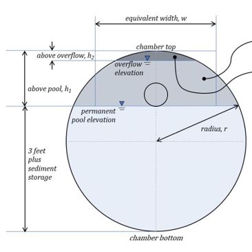
Question: I am using the wet detention pond to model the large diameter pipe that will be used for underground water quality storage. WinSLAMM does not allow the areas in the stage-area data to get smaller as the row number increases. How do I model these types of systems?
Answer: One option is to convert the cross sectional area into the equivalent square pipe size and check that there is at least three feet of dead storage below the outlet invert elevation. Also check that the pipe does not surcharge with an appropriate emergency overflow. It is important to check with your regulatory authority to make sure this approach is acceptable.
See the below graphic from DNR Guidance dated 2/2020, EGAD #: 3800-2020-01 WT-19-0023.
Question: What infiltration rate do I use to model a grass swale?
Answer: The infiltration rate used in the grass swale algorithm is the dynamic infiltration rate. Many resources and field measurements report the static infiltration rate. The dynamic infiltration rate is the static infiltration rate divided by two.
Question: How does the model account for where the BMP is geographically placed within the source area?
Answer: Stormwater controls can be associated with development characteristics (such as disconnecting impervious areas), source area controls (such as rain gardens, parking lot bioretention/biofiltration devices, upland wet detention ponds), drainage system and public works controls (street cleaning, catchbasin cleaning, hydrodynamic devices, grass swales), and end of pipe controls (wet ponds, large infiltration areas), etc. They are associated with specific source areas within each land use (several different roof categories, for example), for several source areas combined, etc. One of the features of version 10 is providing routing of flows and pollutants through simple to complex arrangements of stormwater controls. The model starts at the uppermost controls and routes the flows through each control, adjusting the flow rates, runoff volumes, and pollutant concentrations, according to their features. The stormwater is then passed to the next control or drainage element where calculations continue. Flows also are joined at junctions.
Question: How do you model a multi-stage outlet structure? I have a structure that first allows flow into a small orifice that flows to the outlet culvert. When the water level is high enough it overflows into a 2-foot diameter vertical standpipe. However, that 2-foot diameter flows to a smaller outlet culvert (the same one the first small orifice drains to). If all three are entered, does the program assume direct outflow from each one?
Answer: The program has many options for outlet structure components. Utilize the appropriate component in WinSLAMM for the component in the design. If the design has more components than available (or unusual components), generate a custom stage-discharge curve utilizing all components using standard hydraulic calculations and enter the data into the ‘Other Outlet' option.
Question: Due to scour, some material is lost from the sump during larger runoff events and I believe that regular cleanouts should result in greater material capture. I'm not sure how much more credit would be gained but currently SLAMM doesn't give any benefit for regular cleanout (except to restore sediment storage area if it gets filled). Have you given any thought to factoring in credit for regular cleanout or mandating cleanout more often than to just restore sediment storage area?
Answer: Scour is accounted for by assuming that the devices cannot fill up to anything more than one foot below the outlet of the device. If the devices reach this level, then they can store no more sediment. Detailed CFD modeling and field verifications of WinSLAMM catchbasin sediment accumulation and scour is available at: http://unix.eng.ua.edu/~rpitt/Publications/11_Theses_and_Dissertations/Humberto_Avila_Dissertation.pdf
Question: How would you model a constructed wetland using WinSLAMM?
Answer: In WinSLAMM, you can model a wetland as a wet detention pond for physical settling behavior predictions. The performance will likely be less than a typical wet pond due to the shallow water, and expected scour that WinSLAMM calculates. As an example, sedimentation of particulate-bound P would be predicted, but not reductions in soluble forms due to plant nutrient uptake, or other chemical and biological processes. You could also use a specialized wetland model or a water chemistry model to predict soluble P reductions and then adjust the WinSLAMM outputs.
Question: I am working on a project involving the design of a gravel wetland in WinSLAMM. Unfortunately my results for pollutant load reduction, particularly for Total P, are somewhat less than expected. Guidance on real-world performance of gravel wetlands from the University of New Hampshire's Stormwater Center suggests you can expect ~60% removal efficiency for gravel wetlands. In my models I'm only seeing between 5-10%.
I'm curious if you have experience with these BMPs and how to model them in WinSLAMM - I'm currently using the Bioretention device and creating what I think is approximately correct for a gravel wetland in terms of flow control outlet, saturation, media, etc. Perhaps you could help shed some light on this? It would be greatly appreciated, especially as gravel wetlands are growing in popularity now with Vermont's phosphorus TMDL.
Answer: Currently there is not a specific gravel wetland control practice in WinSLAMM. To model a gravel wetland, the conditions of a gravel wetland will need to be approximated with a control practice in the program that includes the main unit processes, and use assumptions that can be justified to the appropriate regulatory agency.
One option would be to model the device as a biofilter. As you point out, the phosphorus reduction using the biofilter control practice is lower than what the data for a gravel wetland, but performance is highly dependent on the size of the control and other design features. A bioretention device can be described incorporating the physical storage and sedimentation in the ponded portion of the device and in the pores of the gravel layer. Any infiltration can also be entered in the model to describe seepage losses. As noted above, plant nutrient uptake or other chemical or biological processes would not be included, so the results would be conservative.
# Stormwater Control Practices - Street/Alley Cleaning
Question: I have a general street sweeping question. I am working with a municipality to look at the cost effectiveness of implementing some BMP's to get to their 40% removal goal. We did the WinSLAMM modeling for them and I was running their models playing with the street sweeping control device. I found that there was a convex portion of a graph comparing removal vs street sweeping frequency. I included a table below to illustrate.
| Residential Street Sweeping | No Controls | With Controls | Difference |
|---|---|---|---|
| Percent Reduction | TSS (lbs) | TSS (lbs) | Removal |
| Once a Year (Current) | 4376668 | 3554000 | 18.80% |
| Twice a Year | 4376668 | 3552000 | 18.84% |
| Every 12 Weeks | 4376668 | 3577000 | 18.27% |
| Every 8 Weeks | 4376668 | 3570000 | 18.43% |
| Every 4 Weeks | 4376668 | 3555000 | 18.77% |
| Every 2 Weeks | 4376668 | 3518000 | 19.62% |
| Every Week | 4376668 | 3481000 | 20.46% |
| Twice a Week | 4376668 | 3442000 | 21.36% |
| Three Times a Week | 4376668 | 3418000 | 21.90% |
| Four Times a Week | 4376668 | 3408000 | 22.13% |
| Five Times a Week | 4376668 | 3401000 | 22.29% |
| Everyday | 4376668 | 3392000 | 22.50% |
Why does the removal temporarily decrease with frequency?
Answer: The street cleaning routine works by cleaning the streets on the specified frequency you give it. If it rains on the day it's supposed to sweep, the program skips that cleaning (because public works departments don't generally sweep when it rains). Otherwise, it just continues to clean on the days that fall on the specified frequency.
In this specific case, the program is skipping a cleaning due to rain, and thus the sediment removal is reduced. You can compare the "Washoff or Street Cleaning Detail File" for each frequency to see when the model is cleaning. To initialize this file, you check the box in the "Detailed Output Options" form. This effect is greatly minimized with longer rain files.
Question: If you have street sweeping on a SLU file with alleys, do the alleys get swept?
Answer: Because alleys are added to the street source area in Standard Land Use files, the alleys will be swept if street cleaning is applied to the street source areas. The user needs to check that this is appropriate (refer to Street Cleaning and Alleys FAQ).
Question: Can you model street cleaning an alley?
Answer: Street cleaning data only shows effective reductions for street cleaning surfaces with a curb. The street cleaners need to brush against a vertical edge. Therefore, if the alley does not have a curb, street cleaning in the alleys should not be modeled.
Question: When looking at street sweeping removal efficiencies compared to sweeping frequency, there seems to be a reasonable correlation. Sweeping every 12 weeks gave a 1.63% removal, and 7 times a week gave a 26% removal, with reasonable rates in between. However, the Once per year (spring) and twice per year (spring/fall) seem to have unusually high rates (11-12%) compared to the other frequencies. Are these two frequencies calculated a different way?
I understand that if a scheduled sweeping event coincides with a rainfall event in the rain file, the sweeping event is cancelled. In the Green Bay rain file, there are rainfall events on both 4/1 and 10/31, so theoretically the spring/fall scenario would be cancelled, but it still has an 11% removal efficiency. Switching to the 5-year rain file helped out some of the lower-frequency sweepings, but did not change the results of the spring or spring/fall scenarios.
Is there a logical explanation as to why the spring and spring/fall scenarios don't seem to follow the typical trend?
Answer: Research data shows there are large street dirt loads after the winter season for the early spring street cleaning efforts. This winter load is a result of the normal dirt and also the winter sanding practices. Therefore, the street loading curve starts out really high in the beginning of spring, falls quickly due to rain events and early street cleaning and then does a saw tooth pattern through the summer and fall until it snows again. When you clean streets, the street cleaner is taking out some of the dirt along the curve at various times during the year. So, when you clean twice a year, the model takes some dirt from the high part of the curve in the spring and then some from the end of the curve in the fall. When you sweep every 8 or 12 weeks, a majority of the high part of the curve has already been reduced due to rain events and the early few street cleanings, thus the street cleaner removes a smaller average portion of the long term street dirt as most of the loadings throughout the year are substantially reduced compared to the early spring. You can see exactly when the sweeper cleans and the before and after loadings in the detailed output files that are accessed through the "Tools > Default Model Options" screen.
Question: It doesn't seem that my street cleaning control is doing anything in that the "washoff or street cleaning" file (attached w/ .dat) doesn't show any difference between initial and after event loads for street cleaning. It does however, for washoff.
Answer: The reason why it doesn't show any difference is because the before event load is always lower than the MinStDirtRemovalLoad, which is the lowest street dirt load that the street cleaner you have configured can clean to. If you were to run the model with the winter season option, that increases the initial load significantly, which should be, at least initially, higher than the minimum street dirt removal level.
Question: I was wondering if I'm able to use the street cleaning option for paved parking areas and driveways? Our client regularly runs a street sweeper through their parking lot, but I'm unable to input anything for street cleaning for paved parking and driveways w/in the program. I get a message that says "Street Cleaning is not available for this source area". Do you know a way around this? Should I just model the parking lot as a street?
Answer: There is little data regarding the performance of street cleaning in parking lots, so sweeping parking lots it is not included in the model at this time. If appropriate (curbed areas) it is reasonable to designate the main driving lanes as streets and apply street cleaning to those portions of the parking lot.
# Stormwater Control Practices in Series
Question: Can I model practices in series using WinSLAMM?
Answer: Control Practices in series can be modeled in v10 or later versions. The model will route both the particle size distributions and hydrographs through each stormwater control practice. In v9 and earlier versions, very few control practices can be modeled in series. Refer to the documented posted on the Select Documentation page of this website.
# Stormwater Control Practices - Infiltration Practices/Cisterns
Question: How do I model a Green Roof in v10.0?
Answer: A Green Roof can be modeled using the Biofiltration Control Device. The native soil infiltration rate will be set to zero (because traditionally the designer does not want runoff to infiltrate into the actual roof of the building!). The total depth will be the depth of any rock, engineered soil and then a small amount for the default broadcrested weir (all Biofiltration Control devices require a Broad Crested weir as an outlet). The outlets will be an underdrain, evapotranspiration (most important), and the before mentioned broad crested weir. Plant types must be entered for evapotranspiration to occur. If actual evapotranspiration rates are not known, a reference is posted on the Select Documentation page of the website.
Question: I am doing a project in a location where the regulatory agency allows 80% TSS reduction for runoff that flows through an appropriately sized biofilter. I've entered the characteristrics required (soil depth, rock fill, etc) and I'm only getting 60% reduction. How do I modify my model file to account for the reduction allowed?
Answer: The program will allow users to enter a percent reduction instead of calculating it using the research data integrated into the model. To activate this open, in the Media Data form, select the User Defined Soil Type. Close out of the form. Then, in the "Percent Solids Reduction due to Engineered Media (0-100)" enter the allowable percent reduction.
Question: Can SLAMM be used to predict the time it would take the water to stay in the rain garden before it infiltrates or evaporates, etc?
Answer: WinSLAMM reports numerous data regarding the performance of a biofilter, including the ponding durations. To obtain this data, go into the "Detailed Output Options" form under the "Tools" menu and check the box for the "Water Balance File" under the "Biofilters". Then select "Save .INI file". Once you run the model, the program will create a separate comma separated value file in the directory you have the .dat file saved. You can open this file in Microsoft Excel and review the data. Each column in the comma separated value file is defined in the Help File that comes with the program.
The ponding durations reflect the total time water is in the biofilter, including during the rain event itself. To find the net ponding durations (which are generally required for reporting for some regulatory agencies), subtract the rainfall duration from the ponding duration for each event.
Question: I have a couple of questions regarding modeling porous pavement:
DNR Tech Standard 1008 requires that the model be run for the life-cycle of the porous pavement to ensure that the surface infiltration rate never falls below 10 in/hr during the life of the pavement.
- How do you run a multi-year (20-year) analysis?
- Is there a way to view the infiltration rate results of the porous pavement by year?
- Is there a way to model the porous pavement so that the storage reservoir area is greater than the area of the porous pavement?
Answer: To run a 20-year analysis, you will need to select a 20 year (or longer) rainfall file. Under Current File Data, select Edit next to the Rain File, then find an appropriate rainfall file (this should default you to the correct folder). For the Madison area, this will be the WisReg - Madison WI 6392.ran file. This is actually a 30-year rainfall file (1963-1992) so you can run just a subset of the rain events. After you've selected the file, in the Current File Data window, edit the End Date of the rainfall file to 12/30/82. This will ignore all rain events after this date and effectively give you a 20-year rainfall file.
To view the infiltration rate results at the end of each year, you will need to view the Surface Seepage Rate detailed output for porous pavement. Under Tools --> Program Options --> Detailed Output File Options tab, select the Surface Seepage Rate button under Porous Pavement. Selecting this will produce a .csv file for each porous pavement control practice in your model which will be saved in the same location as your .mdb file. Save the .ini and close the window. Next time you run your model, you will generate a .csv called SurfaceSeepageRate. If you open this file, under Column N you will see the maximum surface seepage rate (in/hr) for each rainfall event in your model. Using the dates at the left, you can keep track of this infiltration rate over time.
To model a porous pavement system in which the aggregate base storage reservoir area is greater than the porous pavement area, you will just need to adjust the Porous Pavement Area to Agg Base Area Ratio within the control practice window. As an example, if your porous pavement area is 0.75 acres and your aggregate base storage reservoir area is 0.85 acres, the ratio of Porous Pavement to Base Agg Base Area will be 0.75/0.85 or 0.88. Simply open your porous pavement control practice window within the model and enter this ratio in the last box under the Pavement Geometry and Properties table, hit Continue, then run the model.
# Cost Data
Question: What are the costs for the BMPs based on?
Answer: The pre-determined cost data for all practices except catchbasin cleaning have been developed from the SEWRPC (Southeastern Wisconsin Regional Planning Commission) Technical Report Number 31, "Costs of Urban Nonpoint Surce Water Pollution Control Measures" (June 1991). These costs have been updated to 2005 values by using the Engineering News Record cost indices. In addition, costs are also available from many studies throughout the US and are adjusted by inflation indices for different areas and times. Arvind Narayanan (a UA grad student) summarized this info in his master's thesis, which is the basis for the following report: Arvind and Pitt stormwater cost report
# Model Input and Output
Question: Can I print the model input and output without doing screen captures?
Answer: Yes. To print the model input, select "File" > "Print Input Data". Select "Print Input to File", then "Print". This will prompt a series of forms where you name the input file and select the location where it will be saved. The print the model output, run the model. On the "Output Summary" form, below the pollutant results grid, there are two options for printing. Select either option then follow the prompts to name the output file and choose the location where it will be saved.
Question: I am confused by a term on your Outfall Output Summary. Can you please explain the difference between the two Yields listed: Outfall Total with Controls vs. Annualized Total after Outfall Controls.
Answer: Outfall Total with Controls is the results for the model run for the rainfall file and rainfall dates you chose.
Annualized Total after Outfall Controls takes the "Outfall Total with Controls" and divides it by the "Years in Model Run" to get an annual number.
If you chose a single year rainfall file, then you report the "Outfall Total with Controls" value.
# Model Errors
Question: I keep getting a model error when I am constructing or running model files. However, I cannot duplicate the issue so that I can send the model file and description of steps to get the error to PVA. What do I do?
Answer: Currently this is an issue with some users. One thought is that the user is moving through the program faster than the program can write to the database. Try moving through the program a bit slower than you normally would. If this appears to solve the issue, please send PVA an email to let them know. PVA is exploring options increase the speed the program writes to databases.
Question: My data entry appears to be correct. I get an error when I run the model.
Answer: It is possible the error is due to some computer settings. The WinSLAMM program uses the format "mm/dd/yy". If the computer settings are set to something different, the program cannot do its calculations. To check this, in Windows, go to the "Control Panel: then "Date and Time", then "Change Date and Time", then "Change Calendar Settings". Set the data format to "m/d/yyyy" for WinSLAMM use.
Question: I try to run my model file and I get Error Number 76, Path Not Found. I checked all my parameter files paths and they are all referencing the correct location.
Answer: There are two possible reasons for this error. The first is that the parameter files are located in the "X86" folder on your C:Drive. Windows will not allow the program to access files in this folder. To remedy this, move the parameter files to another folder outside the "X86" folder. A "WinSLAMM Files" directory with the parameter files is created in the root C:Drive and the default file paths reference this folder in an attempt to avoid this issue. The second possible issue is that some of the *.CPZ - particle size distribution - files are not referenced to the correct location. Check the particle size distribution file name and path in both the control practices being modeled as well as in the "Tools" > "Program Options" > "Default Current File Data".
Question: It produces this error on accessing input data. The model allows him to set any model data and then runs fine for output data. It is a fresh model, not a copy/change data. We ran the model on my machine and did not get the error. He is getting the same message no matter what model he runs, this project or otherwise (all work on mine). We are running version 10.3.1
Answer: An overflow error sometimes occurs in the procedure called: proShowCentered in Global_ProcessProcedures. This can occur when you have two monitors with differing dimensions or when you have a monitor hooked up to your laptop. We have not been able to duplicate it on our computer systems, but others have fixed it by starting WinSLAMM on the other monitor.
Question: I get the error message 75: Path/File access error. What do I do?

Answer: The file path is likely too long. Move the file into a folder that is before the current folder to shorten the path.